| East Beach ~ Barrier Beach |
Virtual Field Trip |
| East Beach ~ Barrier Beach |
Virtual Field Trip |
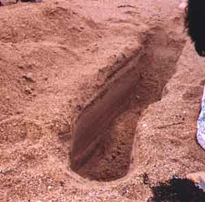
Now that we have seen and examined samples on the wrack line of the beach face, let's dig a trench to determine what lies beneath the sand and complete a scientific transect. Keep going, go down a little deeper. That's good, just about two feet into the sand. Let's discover what we have uncovered in our transect of the sand.
Going down to this lower level, it feels cool and quite damp. Did you notice the stratification, or bands of different color or texture, formed through the sand? By close observance of these bands, we can read the recent storm history of East Beach as if we were reading the rings of a tree. The width of the bands, or lenses, as well as the color changes indicate the intensity of past weather patterns. Lighter tones represent gentler waves while the darker, more coarse sand lenses indicate severe storms. The reason for this is that the more powerful waves carry the heavier sediment further, depositing them on shore.
What is in these darker lenses? It must be the magnetite and black mica we learned was part of the sand's composition. Sand can be pretty different from place to place. Now we know what causes that.