| East Beach ~ Barrier Beach |
Physical Characteristics |
| East Beach ~ Barrier Beach |
Physical Characteristics |
How did the retreat of the glaciers and the development of terminal moraines create the barrier beach and salt pond?As the glaciers melted, sea level began to rise. As the seas rose, water began to fill in the depressions that the glaciers had carved from the earth. The rising seas also eroded and moved the sediments (glacial outwash) that were left behind by the glaciers. These processes left Rhode Island's southern coast with a very irregular outline.
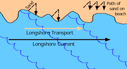
Waves and currents soon began moving and changing the glacial outwash sediments along the coast. As pebbles and rocks broke down, sand was formed. Sand is carried along the shore by longshore currents. These currents travel parallel to shore and carry sand particles suspended in the water. Waves move the sand onto the beach where some of it is deposited and some remains suspended in the water. This movement and deposit of sand particles along the beach is called longshore transport or littoral drift.
As the sand moves, it also collects in shallow areas just off the beach. Sand bars begin to form. As more and more sand is deposited on the bar, it begins to grow. Storms and currents often wash away the sand bar, but if more sand is deposited than is eroded away, the bar will grow and may form a spit. Eventually a long island is formed as more and more sand is added to the spit by longshore drift.
A shallow lagoon (or what Rhode Islanders call salt ponds) forms behind or landward of the sand island. This sand island is called a barrier island because it forms a barrier between the land and the sea. Sometimes the islands connect to the land at one or both ends and the long, narrow beach that remains is called a barrier beach. The Ninigret Salt Pond and East Beach barrier beach system developed in this way.