(Courtesy of Prof Guy Bate)
|
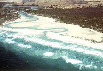
The Heuningnes estuary is Africa's southernmost estuary. The estuary is bounded by the Indian Ocean in the south and agricultural lands in the north. It extends approximately 7.5 miles (12 km) across the coastal plain of the Zoetendals Valley in South Africa farmland. The Heuningnes has a minimum depth of 0.5 m (1.6 feet) and a maximum depth of 2.5 m 8.2 feet. The average water temperature varies from 68°F in the summer to 56°F in the winter. The estuary has a tidal influence for 12 km (7.5 miles) upstream. The mouth of the Heuningnes estuary has been kept open artificially for over 25 years. There are areas near the mouth where the tidal activity has been curtailed due to road protection levees and terrestrial plant species that encroach on the land. Because it is Africa's southernmost estuary, the Heuningnes is scientifically important to species distribution. There are at least three tropical species that are found within the estuary, a ginger prawn, a giant mud crab, and a tropical gastropod. The Heuningnes Estuary is the southernmost recorded area where these species are found. There are many other marine and freshwater species that inhabit the estuary. Bordering the estuary is a nature reserve managed by the Western Cape Nature Conservation Board. The public is able to use the estuary here for recreation such as hiking and fishing. There are some adverse factors that are affecting the health of the estuary. The use of off road vehicles has become a problem on the beach and dunes. There is also a risk of oil-pollution from oil that has been spilled at sea. Development along the coast of South Africa has also increased therefore affecting the land around the estuary. In addition to these problems, pesticides being used on in agricultural activities are polluting the estuary.
|