(Courtesy of Jaime Palter)
|
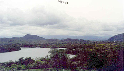
Standing on one of the dirt roads which snakes its way through the Tilaran mountain chain in Costa Rica, you can just make out the Gulf of Nicoya on the edge of the horizon, if it's a clear day. The Gulf of Nicoya is the largest estuary in Costa Rica and is stunning to look at, both from thousands of meters above it and floating within its bath-temperature waters. It is studded with islands and surrounded, at different parts, by sandy beaches, rocky cliffs and mangrove swamps. The Gulf of Nicoya is a cross between a tectonic estuary and a drowned river basin estuary. Where the Tempisque River dumps its muddy waters into the Gulf, at its northern end, it is shallow and has a muddy bottom. In the rainy season there is so much mud, or sediment, in the water of the northern gulf that your hand disappears only a few inches under the surface of the water. Mangrove swamps thrive along the edges of this part of the Gulf. Mangrove swamps are ecosystems with low, leafy mangrove trees, which send their roots deep into dark mud on the shore of an estuary. In Costa Rica, the mangroves' lush leaves provide nesting sites for birds, monkeys, and sloths. The water and mud at their roots offer shelter for thousands of crabs, snappers, clams, muscles, crocodiles and many other species. When storms come in over the ocean, the mangrove swamp provides a buffer zone between the water and the inland. The roots of the trees hold onto the soil to prevent erosion. In Costa Rica mangrove swamps are protected as the gem they are. The law says that no one may cut down even one limb of a mangrove tree. The fresh water in the Tempisque River supplies nutrients to the upper Gulf, enabling algae to flourish. The abundant algae are at the base of a rich food chain that supports much of the economy around the Gulf. Men in small fishing boats float on these usually-calm waters, digging for shellfish in the mud, trapping lobsters and crabs, and pulling fish from lines. Women have formed cooperative groups in communities along the shore. They get together and, while some dig for shellfish to eat or sell for a small profit, others watch the children. Many lives depend on food from the Gulf. For some months during some years, no one can harvest shellfish. Shellfish filter algae out of the water for food. Occasionally, communities of algae in the Gulf are dominated by red tides, called this because of their reddish color which can turn the water brick-colored when the algae is abundant. Unfortunately, red algae often have toxins in their cells along with their red pigments. The toxins in the red tides can build up in the tissue of shellfish and can be harmful to humans, causing anything from skin rashes to paralysis when eaten in quantity. During and after the months when red tides are found in abundance in the Gulf, no one can sell shellfish from the area. There have been red tides in the Gulf of Nicoya as far back as any fisherman can remember. However, until the 1980s, there were no reported cases of sickness. Some women's cooperatives are trying to develop tourism around the northern part of the gulf. Currently, very few of Costa Rica's thousands of tourists visit this part of the country. Its beauty is unquestionable, but the area remains largely undeveloped for tourism. The lower, or southern, Gulf of Nicoya is as spectacular as the northern part, but very different. The water is much deeper-- between 100-600 feet. The bottom waters, which are not warmed by the sun, can be up to 15 C cooler than the water on top. The water is saltier and clearer than the upper Gulf. There are many fish in the lower Gulf by far fewer shrimp and shellfish. The lower Gulf has a sandy or rocky bottom since most of the mud that clouds the waters of the upper Gulf settles out before reaching the lower Gulf. The shore of the lower Gulf is mostly rocky cliffs and sandy beaches, where tourists often vacation, enjoying the magnificent ecology of the area. |