| Ninigret Salt Pond |
Physical Characteristics |
| Ninigret Salt Pond |
Physical Characteristics |
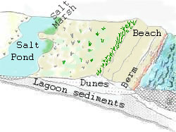
How did salt ponds form?Salt ponds (coastal lagoons) and barrier beaches are formed together as a complex. The shallow salt pond forms behind or land ward of the barrier beach. The diagram below shows you the parts of the barrier beach- salt pond complex as you go from the sea towards land: beach, dunes, salt marsh, and salt pond (lagoon).
Barrier beaches and coastal lagoons in Rhode Island were formed when the sea level rose after the last glacial retreat (melt). The eroding deposits left by the glaciers were the source of sand needed to build the barrier beaches and spits along the coast. Longshore currents moved the sand along the coast and spits of sand began to form. Eventually the spits grew long enough to touch the mainland. This isolated the water behind the barrier spit or beach from the ocean. This now separate body of water is the coastal lagoon or salt pond.
(See the geology section of Barrier Beach's Physical Characteristics for a more detailed explanation of how barrier beaches are formed.)