 | ||||||||||||||
 |
Policy and ManagementDredging & Disposal of Marine DepositsDredging is the process of removing material (sediment, debris, and organic matter) from the bottom of a water body in order to make it deeper. Additional depth in estuaries is usually needed to allow for commercial and or recreational water traffic such as oil tankers, other cargo ships, tour boats, ferries and larger power or sailboats.
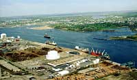
The build up of sediments in an estuary is a natural process that is a result of weathering or erosion of the land due to rainfall. Rainfall carries small particles to streams and rivers. This material is delivered by rivers and streams to estuaries such as Narragansett Bay. In a flowing stream the particles are suspended in the fresh water. However when the particles reach quiet water the energy to keep them suspended is no longer present. Then gravity and density take over, and the sediments settle to the bottom where they collect. Over time they are eventually buried by the continuous delivery of new sediment from the watershed. Many harbors, channels and rivers would eventually fill in if dredging were not performed. In Narragansett Bay, the Providence, Newport, Quonset, Davisville, and Fall River harbors would be inaccessible by anything larger than small vessels without the dredging of channels for navigation. Over the years, between 20 and 25 million cubic yards of material have been dredged out of Narragansett and Mount Hope Bays, enough to fill three lines of bumper-to-bumper dump trucks stretching from Rhode Island to California.
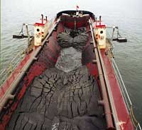
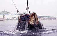
The sediments that accumulate in harbors, particularly in the upper reaches of Narragansett Bay, may be contaminated with a host of heavy metals, man-made chemical compounds, and other potentially serious pollutants. These contaminants pose a risk to humans and marine life when they are dredged up from the bottom of the estuary. Dredging vessels scoop, scrape, or pump the sediments up and transfer them to barges, hoppers or on-shore facilities for disposal. While some material falls back into the water during the process of removal, the greatest management challenge comes from determining where to dispose of the dredged materials.
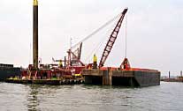
In the past, dredged materials were dumped somewhere close to the harbor such as bordering wetlands, marshes, or deeper locations within the estuary. The development of environmental laws and regulations (e.g., Clean Water Act, Rhode Island Coastal Zone Management Plan) have led to restrictions on where the dredged materials may be dumped. These laws have also led to the development of innovative solutions. Contaminated spoils require special disposal. They are sometimes dumped and then covered with clean sediments. This technique, called "capping", isolates the contaminated material from the surrounding sea life and water. Aquatic Disposal of Dredged Materials Dredged materials are dumped at designated aquatic disposal sites throughout New England in both inshore and offshore locations. Dredged materials must pass stringent tests based on how these materials effect organisms after they are exposed to the material. In addition to capping contaminated materials with clean sediment, another method for confining materials that pose a risk to marine life is to excavate pits in a harbor or channel, place the material in the pit and confine it with clean material. The sediments excavated from the pit generally predate the industrial period and can be reused or dumped in aquatic sites. All aquatic sites that receive dredged materials must be monitored extensively to ensure that the site continues to cause no unacceptable risks to the environment. We have learned a great deal about the behavior of dredged materials from these monitoring efforts. (Refer to Disposal Area MOnitoring System) Beneficial Use of Dredged Materials Rhode Island has recently passed legislation to make it easier to utilize dredge material for a variety of beneficial uses including beach nourishment, road construction, landfill cover, and remediation of contaminated sites. For more information on potential beneficial uses of dredged materials visit the US Army Corps of Engineers and US EPA site at http://www.wes.army.mil/el/dots/budm/budm.html. Providence River Dredging Project A 17-mile navigation channel connects Providence Harbor to deep water near Prudence Island. This channel has not been dredged since 1976. The depths of this channel have been reduced by sediments washing in to as shallow as 30 ft (9.2 m). The US Army Corps of Engineers has developed a plan to restore this channel to its authorized depth of 40 ft (12 m) and width 600 ft (183 m). This proposal calls for placing 1.2 million cubic yards of contaminated dredged material in underwater pits directly under the navigation channel, then capping it. Approximately 5 million cubic yards of non-contaminated material will be dumped at a site in Rhode Island Sound, approximately 10 miles southeast of Point Judith, RI. The Corps also proposes using some of the dredged sediments for beneficial use alternatives, such as restoring nesting waterbird habitat. The Final Environmental Impact Statement for Maintenance Dredging of the Providence River and Harbor Federal Navigation Project is available on-line at http://www.nae.usace.army.mil/news/prvdrv.htm. Resources: Olsen, et. al., An Interpretive Atlas of Narragansett Bay, 1980, pp. 66-69. DAMOS (Disposal Area MOnitoring System) Dredging Operations and Environmental Research (DOER) Activities: "GETTING TO THE BOTTOM OF IT ALL"
|
|||||||||||||