2. How do we measure chlorophyll a?
Chlorophyll a can be measured in several ways.
Individual samples of chlorophyll a are measured by filtering a known amount of sample water through a glass fiber filter. The filter paper itself is used for the analysis. The filter is ground up in an acetone solution and either a fluorometer or spectrophotometer is used to read the light transmission at a given wavelength, which in turn is used to calculate the concentration of chlorophyll a.
Measurements are made with a fluorometer in the field. The water sample is exposed to light of a single wavelength. Some substances in the water sample, including chlorophyll a, will give off light, fluoresce, in response to the light. The amount of light emitted by the chlorophyll a is measured and used to calculate the chlorophyll a concentration. A field fluorometer needs to be calibrated with filtered samples. This is the method used on the buoys in Narragansett Bay.
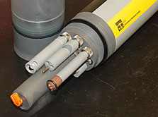 |
This instrument measures temperature, salinity, dissolved oxygen and chlorophyll. The large probe at the bottom is the fluorometer that is used to calculate chlorophyll concentrations.
(Click for larger image) |
Chlorophyll a is also measured remotely by satellite. Satellites measure the color of the ocean to determine the amount of chlorophyll present. The ocean color is often blue, but the satellite can detect very small changes in the ocean color as a result of the chlorophyll in phytoplankton. Satellite measurements need to be compared to field measurements to calibrate the satellite measurements. Satellite measurements allow a look at a very large part of the ocean at the same time. A ship or a buoy could never gather as much information. But measurements from a ship or a buoy can be made throughout the water column and can be related to other measurements made at the same time.
For more information about measuring chlorophyll from space go to the NASA SEAWIFS project page:
http://seawifs.gsfc.nasa.gov/SEAWIFS.html
 |
 |
 |
| (Click for larger images) |
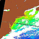
| The left image shows the chlorophyll a on the U.S. East Coast from the SeaWiFS instrument on the SeaStar satellite. Yellow and red colors represent higher chlorophyll, dark blue colors represent lower chlorophyll and brown is land. The right image shows a map of the area covered in the left image. The image is a composite from November 4, 2001 to November 5, 2001. The image was provided by the SeaWiFS Project, NASA/Goddard Space Flight Center and ORBIMAGE.
http://seawifs.gsfc.nasa.gov/SEAWIFS.html |
|