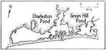
| East Beach ~ Barrier Beach |
History of the Breachway |
| East Beach ~ Barrier Beach |
History of the Breachway |
Jump to Diagram Below1600 - 1700's
The breachway closed in the spring. The farmers and fisherman would dig a breach by hand, using horse-drawn scoops and shovels to make a passage for anadromous fish, or fish born in freshwater which eventually swim to the ocean.1700's
Natural breachway was evident. By 1752 sediment had filled in and boats could not travel through the breachway.1904 -1910
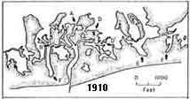
A fifty foot wide breachway was dredged and reinforced with a 200 foot fieldstone jetty to prevent shoals (sand banks) and the closing of the breachway.1912
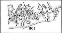
Storm damaged the breachway wall which caused the canal to be closed. Following this, the breach opened and closed naturally.1938
Hurricane swept over the barrier, cutting seven surge channels through East Beach, washing dunes into the pond all the way back to Rt.1 in Charlestown.1952
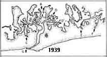
The state of R.I. paid $64,790 dollars to have the breachway dredged to a depth of 3 feet and a width of 120 feet to build stone jetties that extend into the sound from the breachway.1954
Hurricane Carol washed houses, barns, and boats into the water and increased transport of sediment through the breachway.1962
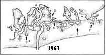
Channel to Green Hill Pond was dredged to connect it directly to Charlestown breachway.1978
Blizzard in February was an intense winter storm causing a great amount of sand erosion on the beach.1979-present
Relatively fair weather period. Since 1978, dune growth has advanced resulting in an increase of buildable ocean front real estate.