 |
 |
Estuarine Science

Fresh Water Input to Narragansett Bay
Taunton River
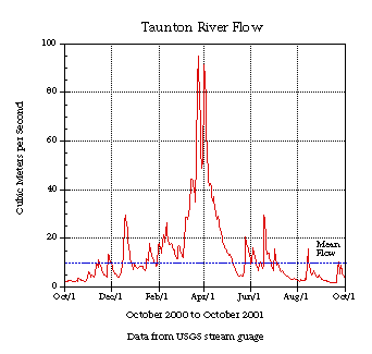
The Taunton River begins in Bridgewater, MA and flows 36 miles into Mount Hope Bay. The watershed includes 38 communities in MA and RI. The watershed includes many cranberry bogs and Hockomock Swamp, the largest wetland in Massachusetts. For more information about the Taunton River, go to The Massachusetts Watershed Initiative web page: http://www.state.ma.us/envir/mwi/watersheds.htm
The Taunton River Watershed
| Click for a map of the Taunton River Watershed. |  |
 
 (Image credits are listed in Image Index)
|
 |


