Environmental Protection Agency Narragansett Bay Commission University of Rhode Island Inner Space Center

Estuarine Science

Salinity

1. What is salinity?
2. How do we measure Salinity?
3. What is the salinity of Narragansett Bay?
4. What can we learn about Narragansett Bay by measuring salinity?
5. Why is the ocean salty?


3. What is the salinity of Narragansett Bay?

The average surface salinity of Narragansett Bay is between 24 and 32 ppt . The bottom water is always saltier (higher salinity) than the surface water. The salinity varies in different parts of the Bay. Near rivers, the salinity will be lower and near the ocean the salinity will be higher. In the Providence River near the hurricane barrier, the salinity can be as low as 13 ppt after a large rain storm.

Factors affecting the salinity of Narragansett Bay:
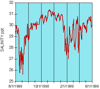
Salinity (ppt) at the URI Bay Campus dock in 1998 and 1999. The highest salinity tends to occur in the winter. Lower salinities generally occur in the spring when there are large rain storms.

What is the salinity in the open ocean?


1. What is salinity?
2. How do we measure Salinity?
3. What is the salinity of Narragansett Bay?
4. What can we learn about Narragansett Bay by measuring salinity?
5. Why is the ocean salty?


(Image credits are listed in Image Index)

Please Note: This website is maintained as an archive of the project. This website is no longer under development.

Home | Estuarine Science | Policy and Management | History and Culture | Virtual Field Trip | Biota Gallery | Maps | Glossary | Teacher Resources | Image Index | Site Info