 | |||||||||
 |
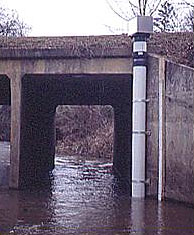
Estuarine ScienceFresh Water Input to Narragansett BayFresh water enters Narragansett Bay from rivers and groundwater. The three main rivers bringing fresh water to Narragansett Bay are the Blackstone, Taunton, and Pawtuxet. The rivers draining into Narragansett Bay have a combined drainage area of 4,790 square kilometers (1,849 square miles) of land. Most of this drainage basin is in Massachusetts. The average fresh water from all rivers is about 2.1 billion gallons a day (8 million cubic meters). In contrast, the total volume of the Bay is about 706 billion gallons. Daily river fresh water input is less than 1% of the volume of Narragansett Bay. River flow is well known because the USGS measures stream heights with automated guages on a thousand rivers nationwide. The realtime and historical stream gauge data for Massachusetts and Rhode Island can be seen at http://ma.water.usgs.gov/
Groundwater input is important but poorly known in Narragansett Bay. In some drainage basins, the river input to the Bay is 70% of the fresh water input and groundwater is 30% of the fresh water input. Sewer input to the Bay may be as much as 10% of the fresh water input at some times. Fresh water will also enter the Bay in small streams and creeks, by sheet runoff during storms, and by rainfall directly on the Bay. These sources are hard to measure. Freshwater input is not constant; there are seasonal variations and individual rain or snow storms. More fresh water from rivers enters the Bay in the winter and spring. Big rainstorms can bring a lot of fresh water to Narragansett Bay over a very short time. This big input of fresh water is a large influence on the conditions in the Bay (see the tidal cycles page). The links below will take you to a page about each of the major rivers draining into Narragansett Bay.
|
||||||||